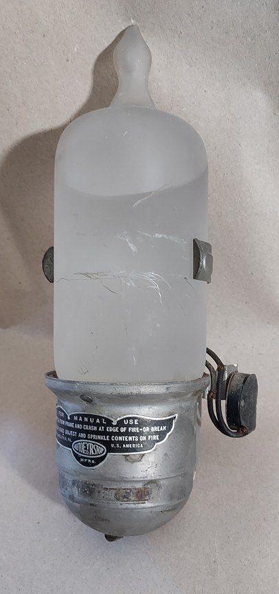
Dorchester Illustration 2660, Handstand at Malibu

Handstand at Malibu

Dorchester Illustration 2660

This week, we are looking for information.  The illustration is of a man performing a handstand at Malibu Beach.

Does anyone know how Mailibu Beach got its name?  Send your answer to   info@dorchesterhistoricalsociety.org 

Posted in Uncategorized | Tagged , , , , | Comments Off on Dorchester Illustration 2660, Handstand at Malibu

Dorchester Illustration 2659, King Square

King Square

Dorchester Illustration 2659

The intersection of Adams Street, Neponset Avenue and Parkman Street is known as King Square.  

The image at the top of today’s illustration is an image of King Square, looking south from approximately where Gibson Street ends at Adams Street. The image comes from a postcard, postmarked Sept. 11, 1912, with title View of King Square, where Neponset Avenue begins.

In the postcard view, Neponset Avenue is to the left side of the house at the point. The street with the trolley car is Adams Street and the building to the right of the trolley car, on the south side of Parkman Street, is 359-365 Adams St.  

The house disappeared from the maps between 1918 and 1933 and was replaced by a Beacon Oil gas station. The three-decker at the very right, 349 Adams St., does not appear on the 1910 map but does appear on the 1918 map.  The postmark date and the map means that the three-decker was constructed in the range of years from 1910 to 1912.  The tax assessing records show that in 1911 Michael Maynes had a “house erecting” there, and in 1912, occupants had moved in: John W. Connelly, 38, lawyer; Charles H. Spear, 43, machinist; and Arthur M. Fraser, 23, machinist.  

The building with the awning at the corner of Adams Street and Parkman Street, on the north side of Parkman Street, had a bakery on the first floor. The bottom image shows the first floor of the building a few years earlier, when Chamberlain’s Pharmacy occupied the storefront on the left of the building and a bakery occupied the storefront on the right side.

Posted in Uncategorized | Tagged , , , , , | Comments Off on Dorchester Illustration 2659, King Square

Dorchester Illustration 2658, Eaton Tavern

Eaton Tavern

Dorchester Illustration 2658

The Eaton Tavern was located in the triangle of land at the foot of Meeting House Hill, near St. Peter’s Roman Catholic Church.  The little park is now known as Father Coppens Square. Over the years it has been called Percival Square, Eaton Square, Dorchester Square, and Father Francis X. Coppens Square.

It is said that American troops gathered at Eaton Tavern in 1775 to participate in the fortification and defense of Dorchester Heights. They would have joined the wagons coming from all directions to Boston Street, converging there to proceed to the Heights, now in South Boston.

Parson Eaton kept a grocery and general store at this location and entertained parties in a hall in the house, which was a local landmark. The tavern contributed to the social life of Meeting House Hill, which was the cultural center of the town. His son, Ebenezer, carried on the business.

The following is from William Dana Orcutt. Good Old Dorchester: A Narrative History of the Town. (Cambridge, 1893).

[Ebenezer Eaton] “was born June 8, 1787, at Meeting-House Hill, in Dorchester, on the site of what is now called Eaton Square. He was at one time a captain in the militia, and retained the title of  “Captain” until his death. After his marriage to Mrs. Mary Withington, a daughter of Thomas Moseley; they lived in the house above mentioned.

“In politics Captain Eaton was a democrat, and held the position of inspector of the Custom House for many years. After his removal by a change in administration, he became an auctioneer and appraiser, and held the office of selectman. He also represented the town in the Legislature. Although Dorchester was a strong Republican town, he never was defeated at the polls. For many years, together with E.E.R. Ruggles and Lewis F. Pierce, Captain Eaton was a member of the “old board” of selectmen, which managed their part of the town affairs with prudence and discretion.  He was also one of the trustees of the Dorchester Savings Bank.” 

Ebenezer died in 1874.

Posted in Uncategorized | Tagged , , , , , | Comments Off on Dorchester Illustration 2658, Eaton Tavern

Dorchester Illustration 2657, May Yohe

May Yohe

Dorchester Illustration 2657

Some Dorchester residents live here all their lives, others arrive and stay a long time. But sometimes people are here only a year or two, but their stories are still interesting. I think that is the case with the riches to rags story of May Yohe.

The top photograph shows May Yohe as a young woman and the bottom photo was taken while she was living in Dorchester in 1934.

May Yohe was born in Bethlehem, Pennsylvania, in 1866. She became a famous star of the stage in her 20s and was considered a beauty. Her debut took place in Chicago in a role in The Arabian Nights. The following year she appeared at the Fifth Avenue Theatre in New York City in Natural Gas.

Her romances became a topic of wide interest. She was said to have a relationship with Jack Mason, leading man of the Boston Museum Company. In 1893, she appeared in London in The Magic Opal, and enjoyed the same popularity that she had in America. In 1894 she married Lord Francis Hope, heir of the Duke of Newcastle. May said that she wore the Hope Diamond only twice and declared that it looked like a “bum sapphire.” The diamond had a reputation for causing bad luck. Her husband went bankrupt and May claimed that her stage earnings paid off mortgages on the family estate. She became a close friend of Edward VII, Prince of Wales, who helped her with relations with her snooty in-laws. She didn’t stick around long enough to become a duchess. May eloped in 1901 with Captain Bradlee Putnam Strong, whom she married after the divorce from Lord Hope was finalized. Strong divorced her in 1910. Her third husband was Capt. John Smuts. She returned to the stage but did not meet with the hoped-for success. 

May and John had little money, and May worked as a janitor for a short time. They tried ranching in California, tried farming and running a tearoom in New Hampshire. They came to Boston, where May regained her American citizenship, which she had given up when she married Lord Hope, so that she could work as a clerk in the Works Progress Administration.

May and John Smuts lived at 11 Granville St. in Dorchester from 1931 to 1933 and later lived at 406 Gallivan Boulevard.  May died in an apartment in the Back Bay in 1938.

“Whatever I do, I do with all my heart. I have learned in life’s school that the only independent woman is the one who can rub a few hundred dollars of her own earnings and savings together in her purse; a dead-broke woman is a football that any clown can kick.”

Posted in Uncategorized | Tagged , | Comments Off on Dorchester Illustration 2657, May Yohe

Dorchester Illustration 2656, Geraldine Trotter

Geraldine Trotter

Dorchester Illustration 2656

The Boston Women’s Heritage Trail has posted a new trail for Upham’s Corner on their website: https://bwht.org/dorchester-tour/

The following is from the entry on the trail for Geraldine Pindell Trotter, who lived at 97 Sawyer Ave.

“Geraldine Trotter was a Boston-born civil rights activist in the early 20th century who moved to Dorchester after her marriage in 1899. She served as the associate editor of The Boston Guardian, an African American newspaper, co-founded by her husband William Monroe Trotter, which was considered radical at the time because it challenged white progressives who largely saw race relations as a southern problem. Her editing and bookkeeping skills were instrumental in keeping the paper afloat. Her death from pneumonia at age 46 during the 1918 influenza epidemic is seen as one reason for its loss of influence. … “She is celebrated in composer Francine Trester’s “A Walk in Her Shoes,” a musical composition premiered by the Boston Landmarks Orchestra in 2021.”

The Dorchester Historical Society is hosting a program about the Upham’s Corner Trail via Zoom at 3 p.m. on Saturday, March 9. Use this link to register https://www.dorchesterhistoricalsociety.org/event-details/on-the-trail-of-womens-history

Posted in Uncategorized | Tagged , , , , | Comments Off on Dorchester Illustration 2656, Geraldine Trotter

Dorchester Illustration 2655 Fowler Clark Epstein Farm

Fowler Clark Epstein Farm

Dorchester Illustration 2655

Historic Boston Incorporated announced on January 17, 2024, that it has sold the Fowler  Clark Epstein Farm at 487 Norfolk Street to the Urban Farming Institute.

Today’s illustration includes a mural (top) of the farm that was discovered on one of the walls in the house.  It depicts the farm in a much earlier period when the land in the area was devoted to agriculture. The farm was once part of a 330- acre estate. The bottom illustration is an image from Google streetview showing the house and barn in its current urban setting.

The property was designated a Boston Landmark in 2006. HBI purchased the property from the Epstein family and, in collaboration with The Trust for Public Land, the North Bennet Street School, restored the original farmhouse and barn.  They created planting beds on the open land in front of the buildings. 

Posted in Uncategorized | Tagged , , , | Comments Off on Dorchester Illustration 2655 Fowler Clark Epstein Farm

Dorchester Illustration 2654 Community Church of Neponset

Community Church of Neponset

Dorchester Illustration 2654

On Nov. 1, 1927, the Appleton Methodist Episcopal Church (organized March 1848), combined with Trinity Congregational Church (organized May 11, 1859), to form the Community Church of Neponset at 51 Walnut Street. It was sometimes called the Church of the Unity, and now it is the Community Church of Neponset.

The top photo of today’s illustration shows a picture of the church published in a flyer about services resuming in the first decade of the 20th century. It is odd that the church was still called the Appleton Methodist Church at that time. The bottom photo shows the church as it looks today. From a study of atlases, the building seems to be same one, remodeled at some point in the 20th century, but no building permit was found for the alterations. We are not sure when the name of the church was changed to Community Church of Neponset.

Posted in Uncategorized | Tagged , , , , | Comments Off on Dorchester Illustration 2654 Community Church of Neponset

Crescent Avenue Station, Dorchester Illustration 2653

In the late 19th century, the Old Colony Railroad train station was located at the end of Crescent Avenue, about two blocks south of the current JFK station on the MBTA’s Red Line. The Old Colony Railroad was constructed along Dorchester’s eastern boundary in the 1840s. The stations in Dorchester were at Crescent Avenue, Savin Hill, Pope’s Hill, and the Shawmut Branch Railway had stations at Fields Corner, Shawmut and Ashmont and Neponset.

Posted in Uncategorized | Tagged , , | Comments Off on Crescent Avenue Station, Dorchester Illustration 2653

Dorchester Illustration 2652, 22 Morrill Street Then and Now

This house at 22 Morrill St. was built in the 1890s. It was bought by William H. Brown and Catherine Brown in 1926. The Browns owned the house until 1938, when they failed to make the mortgage payments.

Today’s illustration is a picture of the house from November 1941, at the time the Mt. Washington Co-operative Bank was selling the house at a price of $4,200. The house was owned by the bank until Herbert L and Helen M. Dill purchased it in 1942.

A few street lights of the type seen in the foreclosure photo can still be found in Dorchester along Wellesley Park.

Posted in Uncategorized | Tagged , | Comments Off on Dorchester Illustration 2652, 22 Morrill Street Then and Now

Dorchester Illustration 2651, Edward Everett Birthplace

Edward Everett Birthplace

Dorchester Illustration 2651

Today’s image is an engraving from 1873 of the Edward Everett birthplace at the Five Corners, now known as Edward Everett Square. The house was taken down in 1898 for the widening of Columbia Road. The site is now occupied by an oddly-shaped three-decker and a Dunkin Donuts store as you can see here

https://www.google.com/maps/place/42%C2%B019’14.3%22N+71%C2%B003’39.7%22W/@42.3206415,-71.0610352,17z/data=!3m1!4b1!4m4!3m3!8m2!3d42.3206415!4d-71.0610352?entry=ttu

Edward Everett went on to become governor of Massachusetts and U.S. Secretary of State among other accomplishments. The origin and early history of the house are described in Appleton’s Journal, May 31, 1873.

“It is supposed that Colonel Robert Oliver built this house about 1740, and that his son, Thomas Oliver, the last Lieutenant-Governor of Massachusetts under the crown, was either born here or on the estate, which reckoned in his time some forty acres of pasture and marsh. Dorchester might, appropriately, be called the home of governors, she having furnished Stoughton, Tailer, Belcher, Hutchinson, Oliver, Everett, and Gardner to colony or State.

“The son, afterward lieutenant-governor, had a fortune much exceeding that of his father, left him by a grandfather and great-uncle, so that Oliver, pere, did not feel called upon to make any provision for him in his will, beyond the usual mourning-suit and ring.  The younger Oliver removed to Cambridge before the Revolution, where he lived in the elegant seat now known as Elmwood—the residence of James Russell Lowell [the Longfellow House].  … One fine morning in September, 1774, the men of Middlesex appeared in the lieutenant-governor’s grounds, at Cambridge, and wrung from him a resignation, after which he consulted his safety by a flight into Boston. …

“In 1775 [the Dorchester house] was the residence of Colonel William Burch, one of the royal commissioners of customs.   This position was no sinecure, considering that the revenue must be collected at the hazard of the officer’s life. Burch, too, fled, and the house was taken possession of by a detachment of the regiment stationed in Dorchester in 1775. Marks of the occupation are still visible here, as they are, also, in the old Clapp homestead nearby, where the three-cornered orifices made by the soldiers’ bayonets are yet seen in the ceiling.”

Oliver Everett, Edward’s father, purchased the estate after the new government confiscated the property as having been owned by a Loyalist who abandoned his possessions by emigrating to England.

Posted in Uncategorized | Tagged , , , | Comments Off on Dorchester Illustration 2651, Edward Everett Birthplace