
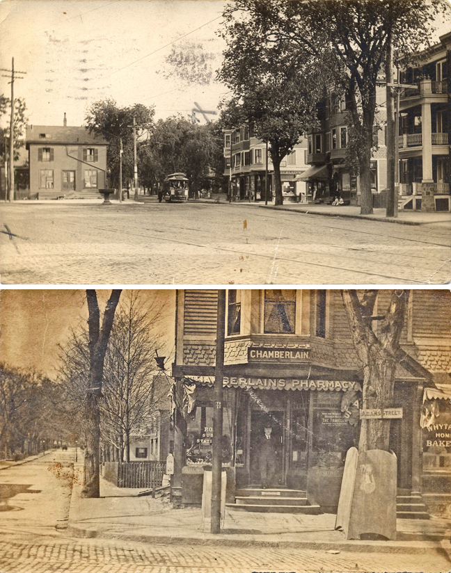
King Square
Dorchester Illustration 2659
The intersection of Adams Street, Neponset Avenue and Parkman Street is known as King Square.
The image at the top of today’s illustration is an image of King Square, looking south from approximately where Gibson Street ends at Adams Street. The image comes from a postcard, postmarked Sept. 11, 1912, with title View of King Square, where Neponset Avenue begins.
In the postcard view, Neponset Avenue is to the left side of the house at the point. The street with the trolley car is Adams Street and the building to the right of the trolley car, on the south side of Parkman Street, is 359-365 Adams St.
The house disappeared from the maps between 1918 and 1933 and was replaced by a Beacon Oil gas station. The three-decker at the very right, 349 Adams St., does not appear on the 1910 map but does appear on the 1918 map. The postmark date and the map means that the three-decker was constructed in the range of years from 1910 to 1912. The tax assessing records show that in 1911 Michael Maynes had a “house erecting” there, and in 1912, occupants had moved in: John W. Connelly, 38, lawyer; Charles H. Spear, 43, machinist; and Arthur M. Fraser, 23, machinist.
The building with the awning at the corner of Adams Street and Parkman Street, on the north side of Parkman Street, had a bakery on the first floor. The bottom image shows the first floor of the building a few years earlier, when Chamberlain’s Pharmacy occupied the storefront on the left of the building and a bakery occupied the storefront on the right side.